🌍 Morocco Geography Guide · 2026 Where Is Morocco? The kingdom at the crossroads of Africa, Europe, the Atlantic and the Mediterranean — a geography that shaped three thousand years of history.
32°N · 5°WNorthwestern Africa
2 CoastlinesAtlantic + Mediterranean
446,300 km²Total territory
8 kmFrom Europe (Gibraltar)
 Morocco’s position in northwestern Africa — bordered by the Atlantic to the west, the Mediterranean to the north, Algeria to the east, and the Sahara to the south.
 Morocco sits at one of the world’s most captivating geographical crossroads — poised between continents, climates, and cultures. The answer to “where is Morocco” reveals far more than a point on a map: it is a gateway to three distinct worlds compressed into a single kingdom — snow-capped mountains, golden Saharan dunes, and twin coastlines along both the Atlantic and the Mediterranean.
Morocco’s Position in the World
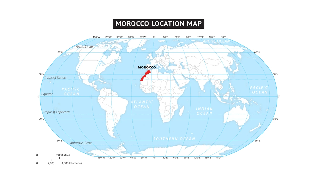
To fully understand where Morocco is, it helps to zoom out and consider its place on the global stage. Morocco occupies the northwestern corner of Africa, located between approximately 27°N and 36°N latitude and 1°W and 13°W longitude. It is the westernmost country of North Africa and the Maghreb region, and it represents Africa’s closest point to the European continent by a significant margin. 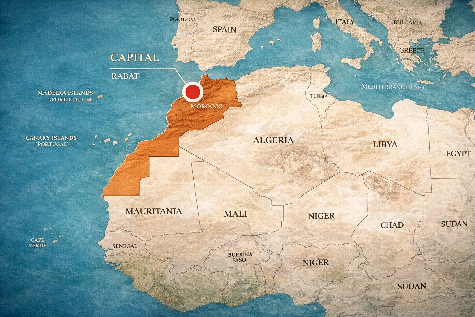 Morocco — a kingdom of contrasts: imperial cities, High Atlas peaks, Saharan dunes, and 2,300 km of Atlantic and Mediterranean coastline. Map courtesy of moroccantraveltrips.com.
 32°N Central latitude — same as Los Angeles and Tel Aviv
5th Largest country in Africa by total area (including southern provinces)
2,300 km Combined coastline on Atlantic and Mediterranean
🌐 Morocco’s Global Coordinates at a Glance
On a world map, Morocco is often the first African country that European travellers encounter — not just conceptually, but literally, given that the ferry from Spain to Tangier takes under an hour. This proximity to Europe has historically made Morocco a cultural relay station, absorbing influences from the Mediterranean world while remaining fundamentally African in its roots. To understand the broader urban landscape of this kingdom, the complete list of cities in Morocco maps out every major centre across all twelve regions. Continent: Africa (Northwestern corner — Maghreb region)
Hemisphere: Northern hemisphere, Western hemisphere
Time zone: WET/WEST (UTC+0 / UTC+1 in summer; Ramadan exceptions apply)
Capital: Rabat (political) — Casablanca is the economic capital
Nearest European country: Spain — 8 km across the Strait of Gibraltar
Distance from Equator: ~3,600 km north — decidedly subtropical to temperate
Morocco — Geographic Position in North Africa & the Mediterranean Hover over countries and cities · Real country outlines (Natural Earth 1:10m) · Mercator projection · Morocco in terracotta
Morocco
Spain / Portugal
Algeria / Tunisia / Libya
Mauritania
Capital / Major city
Ceuta / Melilla
Closed border (since 1994)
Where Is Morocco Located: The Geographic Essentials
The Kingdom of Morocco occupies the northwestern corner of Africa, positioned in the Maghreb region of North Africa. Sitting at approximately 32° North latitude and 5° West longitude, Morocco spans 446,300 square kilometres and serves as Africa’s closest point to Europe. The country is bounded by the Atlantic Ocean to the west and the Mediterranean Sea to the north, making it one of only three nations globally — alongside Spain and France — that boasts coastlines on both bodies of water. This dual-coastline geography has shaped Morocco’s identity for millennia. Travellers can stand on Atlantic beaches watching the sun set over open horizons, then drive north to Mediterranean shores steeped in European character — often within the same day. Morocco to Europe: How Far Is It Really?
One of the most surprising facts about Morocco’s geography is just how close it sits to European soil. The Strait of Gibraltar — the narrow corridor of water separating Morocco’s northern tip from southern Spain — measures only 8 kilometres at its narrowest point, near the town of Tarifa on the Spanish side and Cape Malabata on the Moroccan side. On clear days, the coastlines of both continents are visible to the naked eye from either shore. 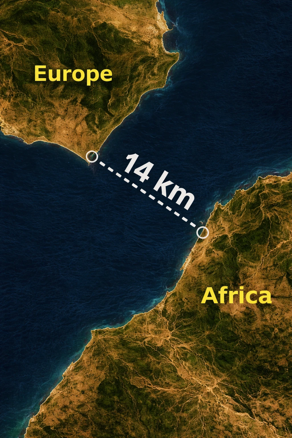 Morocco and Europe separated by just 8–14 km at the Strait of Gibraltar — one of history’s most consequential stretches of water, where Africa meets Europe.
 ✈️ Morocco — Europe Distance by City Approximate distances from Casablanca and Marrakech to major European capitals
🇬🇧
London, United Kingdom Casablanca → London Heathrow
~2,400 km ✈ ~3h 30min direct flight
🇫🇷
Paris, France Casablanca → Paris CDG
~2,100 km ✈ ~3h 10min direct flight
🇪🇸
Madrid, Spain Marrakech → Madrid Barajas
~1,300 km ✈ ~2h 30min direct flight
🇪🇸
Algeciras, Spain (ferry) Tangier Med → Algeciras (Strait crossing)
~35 km ⛴ ~35–60 min by high-speed ferry
🇳🇱
Amsterdam, Netherlands Casablanca → Amsterdam Schiphol
~2,900 km ✈ ~3h 50min direct flight
🇮🇹
Rome, Italy Casablanca → Rome Fiumicino
~2,300 km ✈ ~2h 45min direct flight
🇩🇪
Frankfurt, Germany Marrakech → Frankfurt Airport
~2,700 km ✈ ~3h 30min direct flight
The distance from London to Marrakech is shorter than the distance from London to Istanbul — yet Morocco offers an entirely different continent, culture, and landscape. This is the geographical miracle that makes Morocco so uniquely compelling for European travellers seeking genuine adventure without a transcontinental journey.
Why Morocco’s Location Is So Important for Tourism
Morocco’s geographical position is not merely an academic curiosity — it is the engine of its tourism industry. The kingdom welcomed over 14 million international visitors in 2023, a figure driven almost entirely by the fortunate convergence of geography, climate, and cultural richness that its location provides. Understanding why Morocco’s location matters for tourism requires examining several interlocking factors. 1. Unmatched Accessibility from Europe
No other African country sits so close to the world’s wealthiest and most mobile tourism market. The entirety of Western Europe is within a 4-hour flight from Morocco. Coupled with an open-skies aviation policy that has brought low-cost carriers like Ryanair, easyJet, and Transavia into Moroccan airports, this accessibility has democratised Moroccan tourism — making it viable not just for long-haul travellers, but for European city-breakers seeking a weekend in Marrakech or Fez. 2. Year-Round Climate Diversity Within One Destination
Because Morocco straddles multiple climate zones — from Mediterranean coastal to High Atlas alpine to Saharan desert — it functions as multiple destinations compressed into one. When European beaches close for winter, Morocco’s Atlantic coast and imperial cities remain warm and welcoming. When northern Morocco experiences rain in winter, the Sahara desert remains dry and accessible. This geographic variety eliminates the “off-season” for well-planned Morocco itineraries. 3. The “Africa Without a Long-Haul” Appeal
Morocco’s position allows it to offer genuine African experiences — camel treks in the Sahara, Berber mountain villages, ancient medinas, vast desert silence — without the transcontinental flight that most African destinations require from European travellers. This positioning is commercially powerful: Morocco can simultaneously market itself as “African adventure” to Europeans and “Mediterranean gateway” to Americans and Asians. 4. The Crossroads Effect on Cultural Tourism
Morocco’s geographic location at the intersection of African, Arab, Mediterranean, and European worlds means its culture is layered in ways that most destinations cannot match. A single day in Fez might expose a traveller to Roman ruins, Islamic geometric architecture, Berbère textile traditions, French colonial café culture, and Andalusian musical forms. This multi-dimensional cultural richness, produced directly by Morocco’s crossroads geography, is a tourism asset of incalculable value. 5. Strategic Hub for Multi-Destination Itineraries
Morocco’s location allows travellers to combine a Moroccan itinerary with southern Spain, the Canary Islands (geographically adjacent), the Azores, or West Africa. This multi-destination potential is increasingly popular with long-haul travellers from North America, Asia, and Australia who wish to maximise the value of their intercontinental journey by pairing Morocco with adjacent destinations. 📊 Tourism Impact of Morocco’s Geographic Position
14+ million visitors (2023) — 7th most visited destination in Africa and 1st in North Africa
80+ European cities served by direct flights to Morocco’s major airports
40+ airlines connecting Europe to Morocco, including 15+ low-cost carriers
Year-round viability — every month offers at least two to three ideal regional destinations
Dual continent appeal — simultaneously accessible for European weekend breaks and long-haul travellers
Morocco’s Strategic Position: The Pillars of Hercules
The Strait of Gibraltar — the narrow waterway separating Morocco from Spain — sits at the heart of Morocco’s strategic importance. At just 8 to 14 kilometres wide at its narrowest point, the strait is one of the world’s most significant maritime passages. Ancient Greeks and Romans called these gateway promontories the “Pillars of Hercules”, marking what was once believed to be the world’s edge. Today, approximately 25% of global maritime traffic flows through this passage, connecting the Atlantic Ocean with the Mediterranean Sea. 💡 Did You Know? Ferry services run regularly from Morocco’s northern city of Tangier to Spain — a crossing of roughly 35 minutes. This geographical intimacy explains why Morocco has historically been a crossroads of civilisations: Phoenicians, Romans, Moors, European traders, and modern tourists have all been drawn to this natural gateway between worlds.
Morocco’s Borders and Neighbouring Countries
Where is Morocco located relative to other nations? The kingdom shares land borders with Algeria to the east — a 1,559-kilometre boundary that has been closed since 1994 — and with Mauritania to the south. Spain maintains two North African enclaves, Ceuta and Melilla, on Morocco’s northern Mediterranean coast, remnants of a colonial past that add further complexity to its geopolitical position. These borders tell the story of Morocco’s role as a bridge between the Arab Maghreb and Sub-Saharan Africa, a role that has grown increasingly important for continental trade and investment. The Atlas Mountain Ranges: Morocco’s Geographic Backbone
Running through Morocco like a great spine are three parallel mountain ranges, each creating distinct climates and landscapes that define both the country’s geography and its tourism character. The Rif Mountains
The northernmost range runs parallel to the Mediterranean coast like a verdant rampart. This region receives generous rainfall, supporting lush forests and temperate microclimates. The celebrated blue city of Chefchaouen nestles in these mountains, and numerous gorges and waterfalls attract trekkers throughout the year. The Middle Atlas
Spreading across roughly 350 kilometres through central Morocco, the Middle Atlas presents lakes, cork and oak forests, and volcanic plateaus. This is the realm of Berbère villages and the picturesque town of Ifrane — sometimes called “Little Switzerland” for its alpine character and European-style architecture. The High Atlas: North Africa’s Crown
The High Atlas dominates central Morocco, containing North Africa’s highest peaks. Mount Toubkal rises to 4,167 metres — the continent’s tallest summit north of the Equator. Within hours, travellers ascend from subtropical valleys through cedar forests to snow-capped ridges, then descend toward the Sahara’s golden dunes. This range defines Morocco’s continental climate zones and creates the atmospheric drama that makes Moroccan landscapes so photogenic. The Anti-Atlas: The Southern Rampart
The southwestern Anti-Atlas represents the transition zone between the High Atlas and the Sahara. Drier and lower than their northern counterparts, these mountains feature dramatic gorges, ancient kasbahs, and the spectacular Draa Valley — one of Morocco’s most scenic drives. The Sahara Desert: Morocco’s Southern Frontier
Beyond the Atlas Mountains’ protective barrier lies the Sahara Desert — one of Earth’s most legendary landscapes. The desert occupies Morocco’s southeastern regions, creating an arid world of towering dunes, rocky plateaus, and ancient oases where time seems to move differently. The drive from Marrakech to Merzouga’s famous Erg Chebbi dunes traverses the entire sweep of Moroccan geography: ascending mountain passes, crossing palm-filled valleys, and descending into an amber ocean of sand. Summer temperatures exceed 45°C, while desert nights in winter can drop below freezing. This dramatic transition exists because the Atlas Mountains create a “rain shadow effect,” trapping moisture-bearing Atlantic winds on the western slopes while leaving the eastern and southern terrain parched. This invisible geographical force explains why a single country can contain such radical environmental contrasts within a few hours’ drive.
Coastal Regions: Two Seas, One Nation
The Atlantic Coast
Morocco’s Atlantic coastline stretches over 1,835 kilometres — one of Africa’s most extensive seaboards. This coast is characterised by dramatic cliffs, sandy beaches, working fishing harbours, and cities that blend tourism with authentic maritime culture. Essaouira, with its historic medina and breezy harbour, exemplifies Atlantic Morocco’s bohemian spirit. Agadir, further south, offers some 300 days of annual sunshine and wide sandy beaches that have established it as the country’s premier seaside resort. The Canary Current brings cool water northward along the Atlantic shore, creating a marine layer that moderates temperatures even in summer — making coastal cities comfortable when inland Marrakech bakes in heat. The Mediterranean Coast
The Mediterranean coastline, roughly 500 kilometres long, represents the meeting point of African, Arab, and European cultures. Tangier, Morocco’s northwestern gateway, has served as a crossroads since Phoenician times. The Mediterranean coast features calmer waters than the Atlantic, smaller coves, and an infrastructure shaped by centuries of European interaction alongside deep-rooted Berber and Arab traditions. Climate Diversity: Four Worlds in One Country
Morocco’s geographical complexity creates four distinct climate zones, each shaping the travel experience in a different way. Understanding where Morocco sits geographically helps explain why its climate varies so dramatically from coast to desert to mountain peak. Coastal Cities Mediterranean climate. Mild winters (15°C) and pleasant summers (25°C). Consistent ocean breezes year-round. Casablanca · Rabat · Essaouira · Agadir
Imperial Cities Semi-arid continental. Hot summers (38–40°C) and cool winters (7–18°C). Spring and autumn are ideal. Marrakech · Fez · Meknes · Rabat
Atlas Mountains Temperate highland climate. Cool summers, cold and snowy winters. Best for trekking: spring and autumn. Toubkal region · Ifrane · Chefchaouen
Sahara Desert Extreme desert climate. Scorching days in summer (45°C+) and freezing winter nights. Visit October–May. Merzouga · Zagora · Drâa Valley
Morocco in Continental Context: A True Geographic Bridge
🔗 Strategic Bridges Morocco Commands
Africa and Europe: The Strait of Gibraltar positions Morocco as Africa’s nearest point to continental Europe, making it an essential cultural gateway and trading hub.
The Arab World and Sub-Saharan Africa: Morocco is integrated into the Arab League while serving as West Africa’s natural access point to the Mediterranean.
The Atlantic and the Mediterranean: Few nations command two major ocean coastlines simultaneously — this dual access has made Morocco a crucial logistics hub for centuries.
Cultural Significance of Morocco’s Location
Morocco’s position has shaped its culture in ways travellers feel immediately upon arrival. The kingdom represents a layered blend of African, Arab, Mediterranean, European, and Jewish influences — none of which would have converged without this remarkable geographical crossroads. Berber (Amazigh) Heritage
The indigenous Berbère (Amazigh) people have inhabited North Africa for millennia, long predating any foreign arrival. Their language, Tamazight, is today co-official with Arabic, and their traditions — from architecture and dress to music and craftsmanship — permeate everyday Moroccan life at every level of society. Arab-Islamic Influence
Beginning in the 7th century, the spread of Islam fundamentally shaped Morocco’s religious and cultural landscape. Rather than erasing Berber identity, the two traditions intermingled over centuries, producing the distinctive Moroccan character that persists and thrives today. Jewish Heritage
Morocco has one of the oldest and most significant Jewish communities in the world, with a presence stretching back over 2,000 years. Sephardic Jews expelled from Spain in 1492 found refuge in Morocco, adding new layers to an already rich tradition. Mellah (Jewish quarters) in cities like Fez, Marrakech, and Essaouira remain architectural testaments to this deep-rooted coexistence. European Connection
Centuries of trade, proximity, and colonial history have woven European influences throughout Moroccan society. French remains widely spoken in business and education, Spanish shapes the culture and architecture of the northern coast, and a cosmopolitan sensibility characterises Morocco’s major cities. African Identity
Despite these layered external influences, Morocco’s foundation remains deeply African. Its membership in the African Union, its role in pan-African trade, and the prevalence of African cultural elements throughout society underscore this essential identity — one that ties the kingdom firmly to the continent it anchors from the northwest. For travellers, this cultural fusion means that Morocco offers something genuinely unique: a destination that is simultaneously African, Arab, Mediterranean, European, and Jewish in heritage — yet fully, unmistakably distinct from all of them.
Major Cities and Key Distances
Understanding Morocco’s geography becomes intuitive once you grasp the spatial relationships between its major centres. The country is compact enough to traverse in days, yet varied enough to feel like several countries in one journey. | Route | Distance | Travel Time | Geographical Context |
|---|---|---|---|
| Marrakech → Aït Benhaddou | 180 km | 4–5 hours | Over High Atlas passes (Tizi n’Tichka) |
| Aït Benhaddou → Merzouga | 270 km | 5–6 hours | Desert approach via Drâa Valley oases |
| Marrakech → Essaouira | 190 km | 3 hours | Atlantic coast, coastal argan plains |
| Casablanca → Tangier (TGV) | 330 km | 2 hours 10 min | Atlantic coast, northern plains — Africa’s first HSR |
| Marrakech → Fez (via desert) | 470 km | 10–12 hours | Through Atlas, desert, Saharan plateaus |
| Fez → Chefchaouen | 210 km | 3–4 hours | Middle Atlas to Mediterranean Rif range |
| Morocco → Spain (ferry) | ~35 km | 35–60 min | Tangier–Algeciras across the Strait |
| Casablanca → London | ~2,400 km | ~3h 30min (flight) | Direct transatlantic flight over Bay of Biscay |
| Marrakech → Paris | ~2,000 km | ~3h 10min (flight) | Direct flight across the Western Mediterranean |
Planning Your Journey: Practical Geographic Considerations
Infrastructure Morocco boasts modern highways connecting major cities, Africa’s first high-speed train linking Tangier, Rabat, and Casablanca, and an expanding air network with direct connections across Europe, Africa, and the Middle East.
Seasonal Patterns Geography determines optimal travel by region. Coastal cities are pleasant year-round. Desert regions are best October–May. Mountain trekking suits spring and autumn. Winter is possible everywhere, though the Atlas and desert nights require warm layers.
Travelling Safely Morocco is consistently ranked among the most welcoming destinations in Africa for international visitors. For practical, up-to-date advice before you go, the guide on whether Morocco is safe for tourists covers everything from petty scams to solo travel in detail.
Language Accessibility Arabic and Tamazight are the official languages. French is widely understood across the country, and English is increasingly common in tourist areas and among younger Moroccans and professional guides.
Cultural Respect Modest dress — especially in rural areas and medinas — acknowledges the country’s Islamic traditions. Respecting Berbère heritage and learning a few words of Arabic or Tamazight is always appreciated and opens doors.
The Transformative Power of Morocco’s Location
Morocco’s geographical position — bridging continents, climates, and cultures — is not incidental to the Moroccan experience. It is central to it. When you watch the sun sink over Atlantic dunes, you are experiencing the Sahara’s ancient silence meeting the ocean’s eternal rhythm. When you navigate the labyrinthine lanes of Fez’s medina, you walk through layers of Berbère, Arab, Jewish, and Mediterranean history compressed into a few square kilometres. Understanding where Morocco is located geographically is the first step toward appreciating why it remains one of the world’s most transformative travel destinations — a place where every journey across the landscape is also a journey across centuries of human civilisation. Frequently Asked Questions: Where Is Morocco?
These are the questions travellers ask most often about Morocco’s geography, location, and position relative to the rest of the world. Is Morocco in Africa or the Middle East?
Morocco is firmly in Africa — specifically in the northwestern corner of the African continent, in a region historically called the Maghreb. Although Morocco is an Arab-speaking nation and a member of the Arab League, it is geographically, politically, and culturally distinct from the Middle East. Morocco shares no land border with any Middle Eastern country, being separated from that region by Algeria, Libya, and Egypt to the east. The country is a member of the African Union (since 2017) and is classified by international organisations including the UN as a North African nation.
How far is Morocco from Spain?
At its closest point — between Cape Malabata (Morocco) and Tarifa (Spain) — Morocco is just 8 kilometres from Spain across the Strait of Gibraltar. The ferry crossing from Tangier Med port to Algeciras in southern Spain takes approximately 35 to 60 minutes. By air, the distance from Casablanca to Madrid is roughly 1,500 km (about 2h 30min flight), and from Marrakech to Madrid approximately 1,300 km. Morocco is, without question, the African country geographically closest to Europe.
What countries border Morocco?
Morocco shares land borders with two countries: Algeria to the east and southeast (1,559 km border, officially closed since 1994 due to political disputes) and Mauritania to the south. Additionally, Spain maintains two sovereign enclaves on Morocco’s northern Mediterranean coast — Ceuta and Melilla — which are Spanish territory surrounded by Moroccan land and sea. Morocco also has maritime frontiers with Spain across the Strait of Gibraltar (8–14 km) and with Portugal across the Atlantic Ocean.
What continent is Morocco on?
Morocco is on the African continent. It occupies the northwestern corner of Africa, in the Maghreb region of North Africa. Despite being only 8 kilometres from Europe at the Strait of Gibraltar — the shortest distance between any two continents on Earth — Morocco is undisputedly an African nation. It joined the African Union in 2017 after a 33-year absence, reinforcing its African continental identity.
How far is Morocco from Europe?
Morocco is extraordinarily close to Europe. The Strait of Gibraltar separating Morocco from Spain is only 8–14 km wide — the shortest intercontinental crossing on Earth. By air, direct flights from major European cities range from about 2 hours 30 minutes (Madrid) to 3 hours 30 minutes (London) to 4 hours (Amsterdam or Frankfurt). Distances by air: Casablanca–Paris ~2,100 km; Casablanca–London ~2,400 km; Marrakech–Rome ~2,300 km. No jet lag adjustment is needed for European travellers, as Morocco operates on Western European Time (UTC+0/+1).
What is Morocco’s exact geographic location?
Morocco is located at approximately 32° North latitude and 5° West longitude at its geographic centre, though the country spans from approximately 27°N to 36°N and from 1°W to 13°W. It sits in the Northern Hemisphere and the Western Hemisphere. Its total recognised area is 446,300 km², while the total territory including the southern provinces is approximately 710,850 km². Morocco is the 5th largest country in Africa by total area.
Plan Your Moroccan Adventure Now that you understand where Morocco is and what makes its location so extraordinary — from its closeness to Europe to its deep African roots — the next step is experiencing it firsthand. Whether you’re drawn to Berber mountain villages, ancient imperial medinas, vast desert dunes, or cosmopolitan coastal cities where Africa meets Europe, Morocco’s geographic diversity ensures that no two journeys are ever the same. Morocco’s geographical position ensures that whatever draws you — cultural immersion, adventure, or relaxation — you’ll find it here, often within surprising proximity to other equally compelling experiences. Contact a certified Morocco guide: +212 671 437 971